It’s Friday, so let’s take another drive in Indian Valley! Today we’ll be following Gray’s Creek Rd. There’s some confusion to the unwary traveler involving Gray’s Creek, because there’s Gray’s Creek Rd, South Grays Creek Rd, & North Grays Creek Rd. But today, we’ll be on the “main drag.”
In other news: do keep an eye on Robert Frost’s Banjo this weekend, because you'll see even more exciting announcements here over the next few days!
 Old tires serve many purposes on a ranch—as we turn onto Gray’s Creek Rd, we look south toward Mesa, which is the hill flecked with houses
 A common design of irrigation equipment
 This pic didn’t turn out quite the way I wanted, but those are cedar splits used for fencing stacked up by the hay
 A view to the west (we’ve turned from heading almost due east to almost due north—the plume of smoke may be someone burning a slash pile, a common activity this time of year; slash is the small diameter wood & brush left over after logging
 Love the 55-gallon drums for & tires holding up the trailer! Cool bus & old barn, too
 Dairy cow with sagebrush
 A mullein—these plants are very common throughout the area
 Rangleand & not-so-distant mountains
 A view back almost due south thru the valley from a high point on Grays Creek Rd
 Yesterday was Friday the 13th all right—look what happened in Indian Valley yesterday evening & into the night! As Wallace Stevens said, just a few hours ago right here on this blog:
It was evening all afternoon.
It was snowing
And it was going to snow.
I would say this isn’t supposed to happen for another month, but winters in Indian Valley are so unpredictable—sometimes relatively mild, sometimes long & harsh, & more often than not somewhere in between. There’s a 20% chance of more of the same today, but by mid week temperatures are predicted to be back in the 40s (a bit more seasonable than the 20s & 30s we’ve been getting), & this could all vanish!

In other news: we have some new ventures of the bloggish vairety beginning in the next few weeks, & we’re really excited about them—hope you will be too. Stay tuned, because the first such “roll-out” is coming tomorrow morning, with an announcement right here on Robert Frost’s Banjo!
In the meantime, enjoy these winter wonderland views from the front porch.

Ready to continue our tour thru Indian Valley, ID? Good! Today we’ll have a look at the village itself, & also some farmland just south of the village. Enjoy!
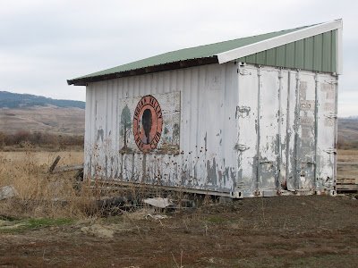 A shed at the Indian Valley Trap Club—most of the towns in this area have a shooting club.
 The trap club & the community hall
 The Indian Valley Community Church—Eberle & I played a wedding there once—with the Adams County Road Department’s Indian Valley shop to the left.
 The Indian Valley general store—yes, it’s open for business! This is a real hang-out for the old-time ranchers.
 Sheep; cows (the black dots on the ridge); irrigation pipe (the white line at the far end of the sheep pasture); one lone tree; mountains in the distance—not the best of the pix, but it does sum up one very large aspect of the valley.
 You do see cattle in the road (along with any number of other creatures ranging from badgers to bears). Adams County has open range laws, which give the cattle some legal standing (so to speak) in the road—many counties in the U.S. west are open range. Of course, it’s one thing to come across cattle on this country road (which has changed from pavement to dirt after we left the little village); it’s another thing to come across them on U.S. Highway 95, with its 65 miles per hour speed limits!
 An old homestead, no longer in use. Even when these homesteads eventually fall to wrack & ruin, the surrounding trees are always a tell-tale sign in this generally treeless rangeland. The homesteaders particularly favored locust trees.
 An old barn on the same property, & this still is used.
 Two horses feeding
 Ah, we’ve reached a fork in the road! Ben Ross Reservoir supplies irrigation water to the local ranches, & is also a favorite fishing hole. The road along the Little Weiser River will fork again, with one branch leading to the little village of Ola & the other leading thru some real rangeland & into the hills & eventually down into Emmet, an area that once was known for its orchards. But we have places closer to home to explore for the time being.
 As we turn “our rig” around, a shot of sage & bitterbrush growing out of a rocky hillside.
Be sure to check in next Friday as we continue our tour!
 We recently became a two camera couple, as Eberle needed to take over our trusty Canon Elph for a top secret project (I expect you’ll read about it right here in the not-too-distant-future), which meant I had to get a bit of an upgrade—still a point & shoot, but one with a lot more features, including considerably more zoom, a Canon PowerShot. As a result I’ve been taking pix like mad, & over the past few days I’ve shot a bit of a “documentary” of Indian Valley. I’ll be sharing those photos here on Fridays this month.
Our house stands a few miles north of the village proper, & we’re beginning with photos taken just north of the village itself. Future installments will take us into the village, then down a few side roads, & eventually bring us back toward “our neck of the woods.” Enjoy!
The pic at the top of the post shows some large hay barns & quonset storage buildings from one of the valley’s larger ranches. The pipe at the front of the photo is for irrigation water.
 An array of irrigation equipment; note the blackened hillside to the right—caused by a cigarette tossed from a car. Verbum sapientis satis est!
 A white "beef" as the local ranchers affectionately term their cattle
 Dilapidated outbuilding with newish John Deere tractor
 Crossing one of the many creeks (pronounced “cricks” locally) that flow thru the valley
 Abandoned equipment: not an uncommon sight
 These are on a lot filled with everything from railroad ties to flatbed trailers; the item to the left is used for spraying weeds
 Another view of the same lot
 Dunham Dairy: not a going concern. Most of the ranching out here is beef cattle, with some sheep ranching. Dairy cattle are uncommon
 Big hay bales, with snowcapped Indian Mountain in the background
 The intersection of Grays Creek Rd & North Grays Creek Rd
 A sign of the times: the fenced-in road on the mostly unpopulated Gray’s Creek Meadows subdivision
 Curious cattle
 Resplendent bitterbrush
 Calf & cow
 Looking west toward Mesa Hill from North Grays Creek Rd
 Looking south back into the Valley from North Grays Creek Rd
 Curious sheep on a nearby ranch
 Heading down the hill back toward our house, we again look south toward the Valley


